 Geocatalogue of the Royal Museum for Central Africa
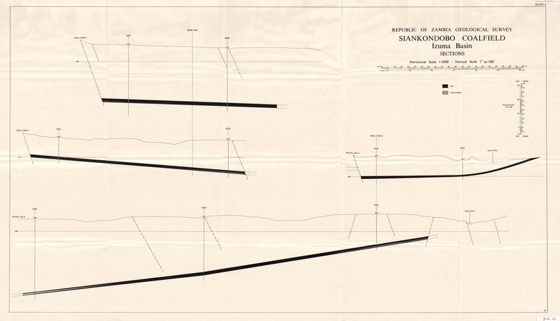
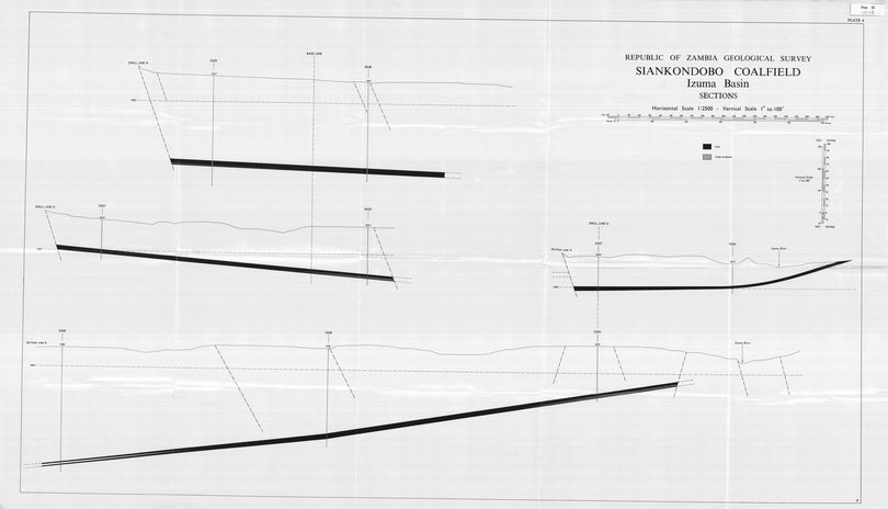
Republic of Aambia - Siankondobo coalfield - Izuma Basin - Sections
Title: Republic of Aambia, Siankondobo coalfield - Izuma Basin - Sections - Scale: 2500 - Map to accompany Economic Report N°16
Plate 4 - Sheet number/Numéro de feuille/Bladnummer: 4
Simple
- Date (Creation)
- 1967-01-01
- Date (creationEndDate)
- 1967-12-31
- Date (creationEndDate)
- 1967-01-01
- Citation identifier
- 001048
- Keywords
-
-
Siankondobo
-
- Keywords
-
-
Zambia
-
- Keywords
-
- Keywords
-
-
ressources minérales
-
- Keywords
-
-
coal field
-
- Keywords
-
-
economic geology
-
- Use limitation
-
© Royal Museum for Central Africa
- Access constraints
- Other restrictions
- Other constraints
-
© Royal Museum for Central Africa
- Denominator
- 2500
- crt:MD_ScaleRemark
-
échelle calculée
- Language
- eng_us
- Topic category
-
- Geoscientific information
- Environment
N
S
E
W
))
- Begin date
- 1967-01-01
- End date
- 1967-12-31
- crt:originType
-
Auteur
- crt:originType
-
Éditeur
- crt:originName
-
Geological Survey Department, Lusaka
- crt:originType
-
Éditeur
- crt:originName
-
Royal Museum for Central Africa
- crt:originType
-
Responsable éditorial
- Codespace
-
RMCA:custom
- Version
-
0.9
- Distribution format
-
-
hardcopy
(
)
-
hardcopy
(
)
- Hierarchy level
- Dataset
Conformance result
- Date (Publication)
- 2014-03-04
- Explanation
-
inapplicable
- Statement
-
Date verification: 2022-09-30 00:00:00, Name verification: EG
- File identifier
- BE-RMCA-EARTHS-001048 XML
- Metadata language
- fre_be
- Hierarchy level
- Dataset
- Date stamp
- 2023-09-06
Point of contact
Royal Museum for Central Africa
-
maps@africamuseum.be
(
Unité Cartographie (Dept. Sciences de la Terre)
)
Royal Museum for Central Africa, Leuvensesteenweg, 13, 3080 Tervuren
,
Tervuren
,
3080
,
Belgium
Overviews

Spatial extent
N
S
E
W
Provided by

Associated resources
Not available