 Geocatalogue of the Royal Museum for Central Africa
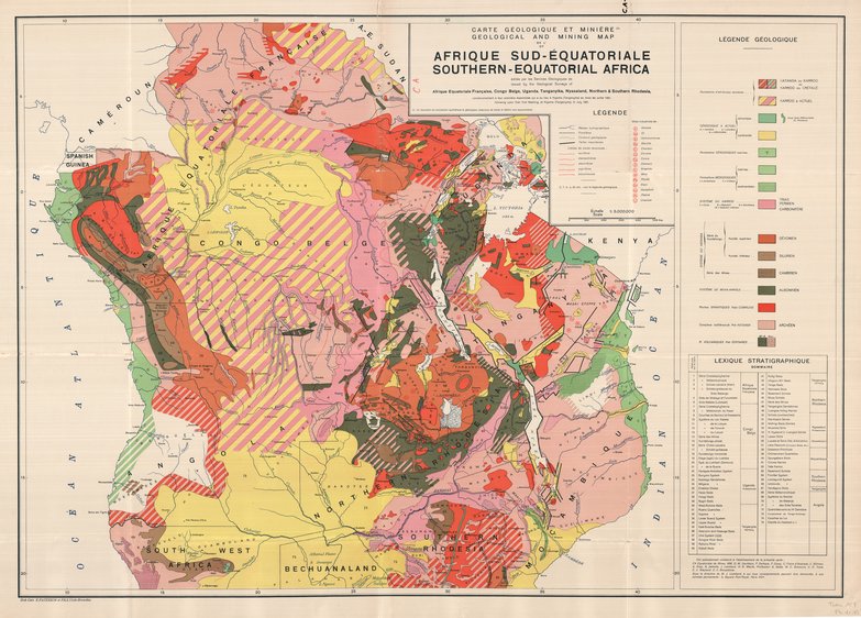
Carte géologique et minière de l'Afrique Sud-Equatoriale - Geological and mining map of Southern-Equatorial Africa
Title: Carte géologique et minière de l'Afrique Sud-Equatoriale, Geological and mining map of Southern-Equatorial Africa - Scale: 5000000
Simple
- Date (Creation)
- 1931-01-01
- Date (creationEndDate)
- 1931-12-31
- Date (creationEndDate)
- 1931-01-01
- Citation identifier
- 007812
- Keywords
-
-
Southern Africa
-
- Keywords
-
- Keywords
-
-
ressources minérales
-
- Keywords
-
-
general geology
-
- Keywords
-
-
geologic map
-
- Keywords
-
-
geology
-
- Use limitation
-
© Royal Museum for Central Africa
- Access constraints
- Other restrictions
- Other constraints
-
© Royal Museum for Central Africa
- Denominator
- 5000000
- crt:MD_ScaleRemark
-
échelle calculée
- Language
- eng_us
- Topic category
-
- Geoscientific information
- Environment
))
- Begin date
- 1931-01-01
- End date
- 1931-12-31
- crt:originType
-
Auteur
- crt:originName
-
Davidson, D.M.
- crt:originType
-
Auteur
- crt:originName
-
Delhaye, F.
- crt:originType
-
Auteur
- crt:originName
-
Dixey, F.
- crt:originType
-
Auteur
- crt:originName
-
Gray, A.
- crt:originType
-
Auteur
- crt:originName
-
Lombard, J.
- crt:originType
-
Éditeur
- crt:originName
-
Geological Survey, Afrique Equatoriale Française
- crt:originType
-
Éditeur
- crt:originName
-
Geological Survey, Congo Belge
- crt:originType
-
Éditeur
- crt:originName
-
Geological Survey, Nyasaland
- crt:originType
-
Éditeur
- crt:originName
-
Geological Survey, Rhodesia
- crt:originType
-
Éditeur
- crt:originName
-
Geological Survey, Tanganyika
- crt:originType
-
Éditeur
- crt:originName
-
Geological Survey,Uganda
- crt:originType
-
Éditeur
- crt:originName
-
Royal Museum for Central Africa
- crt:originType
-
Responsable éditorial
- Codespace
-
RMCA:custom
- Version
-
0.9
- Distribution format
-
-
hardcopy
(
)
-
hardcopy
(
)
- Hierarchy level
- Dataset
Conformance result
- Date (Publication)
- 2014-03-04
- Explanation
-
inapplicable
- Statement
-
Date verification: 2023-04-25 00:00:00, Name verification: EG
- File identifier
- BE-RMCA-EARTHS-007812 XML
- Metadata language
- fre_be
- Hierarchy level
- Dataset
- Date stamp
- 2023-09-06
Overviews
Spatial extent
Provided by
