 Geocatalogue of the Royal Museum for Central Africa
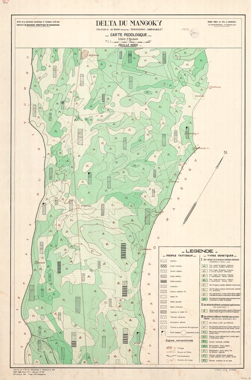
Delta du Mangoky (périmètre de 5000 hectares - Tanandava-Ambahikily) Carte pédologique
Title: Delta du Mangoky (périmètre de 5000 hectares - Tanandava-Ambahikily)
Carte pédologique - Scale: 10000 - Assemblage en 2 feuilles - Sheet number/Numéro de feuille/Bladnummer: Nord
Simple
- Date (Creation)
- 1961-01-01
- Date (creationEndDate)
- 1961-12-31
- Date (creationEndDate)
- 1961-01-01
- Citation identifier
- 008032
- Keywords
-
-
Mangoky
-
- Keywords
-
-
Madagascar
-
-
RMCA:author
-
-
Hervieu, J.
-
-
RMCA:author
-
-
Rakotomiraho, J.D.
-
-
RMCA:author
-
-
Ratasilahy, J.R.
-
- Keywords
-
-
RMCA:centralelibnumber
-
-
26075
-
- Keywords
-
-
geomorphology and Quaternary geology
-
- Keywords
-
-
soil
-
- Keywords
-
-
soil map
-
- Use limitation
-
© Royal Museum for Central Africa
- Access constraints
- Other restrictions
- Other constraints
-
© Royal Museum for Central Africa
- Denominator
- 10000
- crt:MD_ScaleRemark
-
échelle calculée
- Language
- eng_us
- Topic category
-
- Geoscientific information
- Environment
))
- Begin date
- 1961-01-01
- End date
- 1961-12-31
- crt:originType
-
Auteur
- crt:originName
-
Hervieu, J.
- crt:originType
-
Auteur
- crt:originName
-
Rakotomiraho, J.D.
- crt:originType
-
Auteur
- crt:originName
-
Ratasilahy, J.R.
- crt:originType
-
Éditeur
- crt:originName
-
Institut de Recherche Scientifique de Madagascar
- crt:originType
-
Éditeur
- crt:originName
-
Office de la Recherche Scientifique Outre-Mer
- crt:originType
-
Éditeur
- crt:originName
-
Royal Museum for Central Africa
- crt:originType
-
Responsable éditorial
- Codespace
-
RMCA:custom
- Version
-
0.9
- Distribution format
-
-
hardcopy
(
)
-
hardcopy
(
)
- Hierarchy level
- Dataset
Conformance result
- Date (Publication)
- 2014-03-04
- Explanation
-
inapplicable
- Statement
-
Date verification: 2019-11-18 00:00:00, Name verification: EG
- File identifier
- BE-RMCA-EARTHS-008032 XML
- Metadata language
- Français
- Hierarchy level
- Dataset
- Date stamp
- 2025-12-10
Overviews
Spatial extent
Provided by
