 Geocatalogue of the Royal Museum for Central Africa
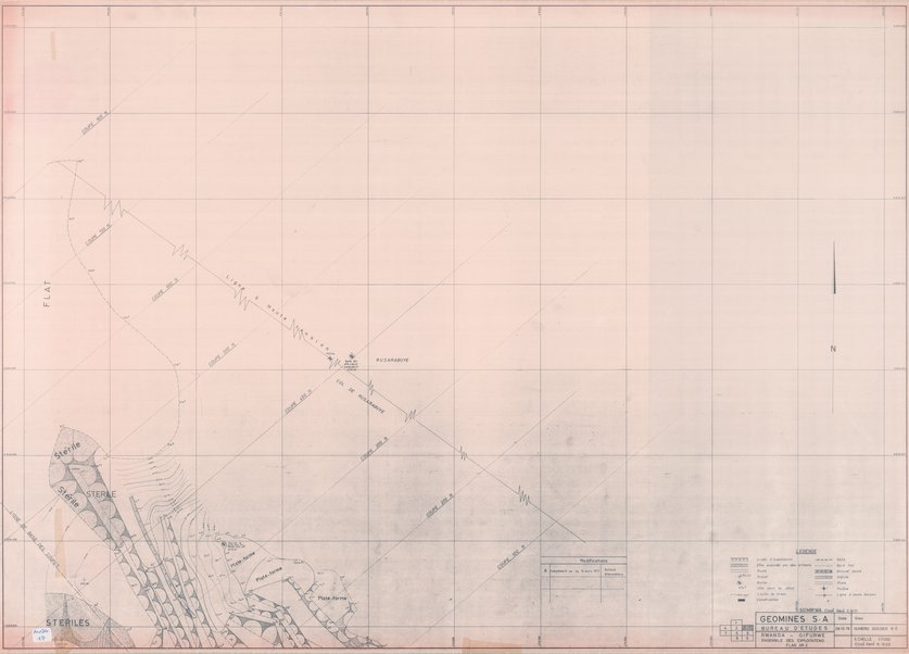
Ensemble des exploitations: plan n° 3 - Rwanda - Gifurwe
Title: Ensemble des exploitations: plan n° 3, Rwanda - Gifurwe - Scale: 1000 - Clast genl R10.59
Simple
- Date (Creation)
- 1976-01-01
- Date (creationEndDate)
- 1976-12-31
- Date (creationEndDate)
- 1976-01-01
- Citation identifier
- 011282
- Keywords
-
-
Gifurwe
-
- Keywords
-
-
Rwanda
-
- Keywords
-
- Keywords
-
-
economic geology
-
- Keywords
-
-
economic geology map
-
- Keywords
-
-
exploitation
-
- Keywords
-
-
exploration
-
- Use limitation
-
© Royal Museum for Central Africa
- Access constraints
- Other restrictions
- Other constraints
-
© Royal Museum for Central Africa
- Denominator
- 1000
- crt:MD_ScaleRemark
-
échelle calculée
- Language
- eng_us
- Topic category
-
- Geoscientific information
- Environment
N
S
E
W
))
- Begin date
- 1976-01-01
- End date
- 1976-12-31
- crt:originType
-
Auteur
- crt:originType
-
Éditeur
- crt:originName
-
Géomines
- crt:originType
-
Éditeur
- crt:originName
-
Royal Museum for Central Africa
- crt:originType
-
Responsable éditorial
- crt:originName
-
Géomines
- Codespace
-
RMCA:custom
- Version
-
0.9
- Distribution format
-
-
hardcopy
(
)
-
hardcopy
(
)
- Hierarchy level
- Dataset
Conformance result
- Date (Publication)
- 2014-03-04
- Explanation
-
inapplicable
- Statement
-
Date verification: 2020-02-20 00:00:00, Name verification: EG
- File identifier
- BE-RMCA-EARTHS-011282 XML
- Metadata language
- fre_be
- Hierarchy level
- Dataset
- Date stamp
- 2023-09-06
Point of contact
Royal Museum for Central Africa
-
maps@africamuseum.be
(
Unité Cartographie (Dept. Sciences de la Terre)
)
Royal Museum for Central Africa, Leuvensesteenweg, 13, 3080 Tervuren
,
Tervuren
,
3080
,
Belgium
Overviews
Spatial extent
N
S
E
W
Provided by

Associated resources
Not available