 Geocatalogue of the Royal Museum for Central Africa
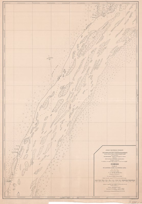
Congo de la rivière Alima à la rivière Sanga Feuille 6 - Reconnaissance hydrographique effectuée en 1911 par la Mission Congo-Oubangui-Sanga
Title: Congo
de la rivière Alima à la rivière Sanga
Feuille 6, Reconnaissance hydrographique effectuée en 1911 par la Mission Congo-Oubangui-Sanga - Scale: 50000 - Sheet number/Numéro de feuille/Bladnummer: 6
Simple
- Date (Creation)
- 1911-01-01
- Date (creationEndDate)
- 1911-12-31
- Date (creationEndDate)
- 1911-01-01
- Citation identifier
- 021309
- Keywords
-
-
fleuve Congo
-
- Keywords
-
-
Afrique-Equatoriale française
-
- Keywords
-
-
Congo R.D.
-
- Keywords
-
- Keywords
-
-
hydrographie
-
- Keywords
-
-
flood
-
- Keywords
-
-
hydrology
-
- Keywords
-
-
geomorphology and Quaternary geology
-
- Keywords
-
-
topography
-
- Use limitation
-
© Royal Museum for Central Africa
- Access constraints
- Other restrictions
- Other constraints
-
© Royal Museum for Central Africa
- Denominator
- 50000
- crt:MD_ScaleRemark
-
échelle calculée
- Language
- eng_us
- Topic category
-
- Geoscientific information
- Environment
N
S
E
W
))
- Begin date
- 1911-01-01
- End date
- 1911-12-31
- crt:originType
-
Auteur
- crt:originName
-
Ardon
- crt:originType
-
Auteur
- crt:originName
-
Baule
- crt:originType
-
Auteur
- crt:originName
-
Debrabant
- crt:originType
-
Auteur
- crt:originName
-
Planchat, M.
- crt:originType
-
Auteur
- crt:originName
-
Roussilhe, M.H.
- crt:originType
-
Éditeur
- crt:originName
-
Mission Congo-Oubangui-Sanga
- crt:originType
-
Éditeur
- crt:originName
-
Royal Museum for Central Africa
- crt:originType
-
Responsable éditorial
- Reference system identifier
- RMCA:custom / Mercator / 0.9
- Distribution format
-
-
hardcopy
(
)
-
hardcopy
(
)
- Hierarchy level
- Dataset
Conformance result
- Date (Publication)
- 2014-03-04
- Explanation
-
inapplicable
- Statement
-
Date verification: 2019-04-08 00:00:00, Name verification: EG
- File identifier
- BE-RMCA-EARTHS-021309 XML
- Metadata language
- fre_be
- Hierarchy level
- Dataset
- Date stamp
- 2023-09-06
Point of contact
Royal Museum for Central Africa
-
maps@africamuseum.be
(
Unité Cartographie (Dept. Sciences de la Terre)
)
Royal Museum for Central Africa, Leuvensesteenweg, 13, 3080 Tervuren
,
Tervuren
,
3080
,
Belgium
Overviews
Spatial extent
N
S
E
W
Provided by

Associated resources
Not available