 Geocatalogue of the Royal Museum for Central Africa
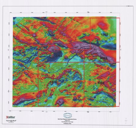
East Kasai Magnetic Gradiometer Survey - Total Magnetic Field Image Preliminary data
Title: East Kasai Magnetic Gradiometer Survey, Total Magnetic Field Image
Preliminary data - Scale: 105000 - ZAI069
De Beers permits
Simple
- Date (Creation)
- 2004-01-01
- Date (creationEndDate)
- 2004-12-31
- Date (creationEndDate)
- 2004-01-01
- Citation identifier
- 039893
- Keywords
-
-
Kasai
-
- Keywords
-
-
Congo R.D.
-
- Keywords
-
- Keywords
-
-
geophysical map
-
- Keywords
-
-
solid-earth geophysics
-
- Use limitation
-
© Royal Museum for Central Africa
- Access constraints
- Other restrictions
- Other constraints
-
© Royal Museum for Central Africa
- Denominator
- 105000
- crt:MD_ScaleRemark
-
échelle calculée
- Language
- eng_us
- Topic category
-
- Geoscientific information
- Environment
N
S
E
W
))
- Begin date
- 2004-01-01
- End date
- 2004-12-31
- crt:originType
-
Auteur
- crt:originType
-
Éditeur
- crt:originName
-
Bugeco
- crt:originType
-
Éditeur
- crt:originName
-
Xcalibur Airborne Geophysics
- crt:originType
-
Éditeur
- crt:originName
-
Royal Museum for Central Africa
- crt:originType
-
Responsable éditorial
- crt:originName
-
Bugeco
- Reference system identifier
- RMCA:custom / WGS 84 / 0.9
- Distribution format
-
-
hardcopy
(
)
-
hardcopy
(
)
- Hierarchy level
- Dataset
Conformance result
- Date (Publication)
- 2014-03-04
- Explanation
-
inapplicable
- Statement
-
Date verification: 2024-07-01 00:00:00, Name verification: EG
- File identifier
- BE-RMCA-EARTHS-039893 XML
- Metadata language
- Français
- Hierarchy level
- Dataset
- Date stamp
- 2025-11-07
Point of contact
Royal Museum for Central Africa
-
maps@africamuseum.be
(
Unité Cartographie (Dept. Sciences de la Terre)
)
Royal Museum for Central Africa, Leuvensesteenweg, 13, 3080 Tervuren
,
Tervuren
,
3080
,
Belgium
Overviews
Spatial extent
N
S
E
W
Provided by

Associated resources
Not available