 Geocatalogue of the Royal Museum for Central Africa
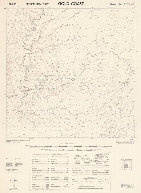
Preliminary plot Gold Coast, sheet 264 north C-31/S-III-NE, Ghana
Cette carte livre des renseignements relatifs à la végétation, à l'emplacement de diverses infrastructures (bâtiments), des agglomérations (villes, villages...), des rivières, etc. dans une entité au Ghana à Gold Coast vers les années 1953.
Simple
- Date (Publication)
- 1953-01-01
- Date (Creation)
- 1953-01-01
- Date (Revision)
- 1953-01-01
- Citation identifier
- CD-CRSN-DOC1004
-
None
-
-
gold coast
-
-
None
-
-
ghana
-
-
GEMET - INSPIRE Themes
-
-
Hydrographie
-
-
GEMET - INSPIRE Themes
-
-
Occupation des terres
-
-
GEMET - INSPIRE Themes
-
-
Bâtiments
-
- Use limitation
-
None
- Access constraints
- Other restrictions
- Other constraints
-
Pas de restriction d'accès public selon INSPIRE
- Denominator
- 50000
- Language
- English
- Character set
- MD_CharacterSetCode_utf8
- Topic category
-
- Inland waters
- Imagery base maps earth cover
- Structure
- Description
-
Liste des emprises
))
- Reference system identifier
- EPSG / urn:ogc:def:crs:EPSG:6.11:4258
- Distribution format
-
-
JPEG JFIF
(
None
)
-
JPEG JFIF
(
None
)
- Protocol
-
http
- Name of the resource
-
Centre de Recherche en Sciences Naturelles (CRSN) Lwiro
- Hierarchy level
- Dataset
Conformance result
- Date (Creation)
- 2010-11-23
- Explanation
-
See the referenced specification
- Pass
- Yes
- Statement
-
Compiled and drawn by Directorate of Colonial Surveys from Control supplied by The Survey Department, Gold Coast and Directorate of Colonial Surveys. Air Photography by Air Survey Co. Ltd., Nov., 1951. Photolithographed and Printed by G.S.G.S. 1953.
- File identifier
- CD-CRSN-DOC1004 XML
- Metadata language
- Français
- Character set
- MD_CharacterSetCode_utf8
- Hierarchy level
- Dataset
- Date stamp
- 2017-09-16
- Metadata standard name
-
ISO19115
- Metadata standard version
-
2003/Cor.1:2006
Overviews
Spatial extent
Provided by
