 Geocatalogue of the Royal Museum for Central Africa
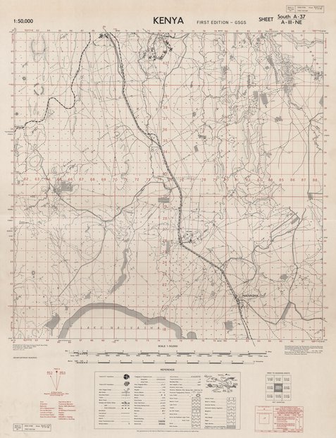
Preliminary plot Kenya, sheet south A-37/A-III-NE
Cette carte localise les infrastructures, les routes, les localités, les différentes forêts, les agglomérations dans une partie du Kenya vers les années 1953.
Simple
- Date (Publication)
- 1953-01-01
- Date (Creation)
- 1953-01-01
- Date (Revision)
- 1953-01-01
- Citation identifier
- CD-CRSN-DOC1113
-
None
-
-
kenya
-
-
GEMET - INSPIRE Themes
-
-
Occupation des terres
-
-
GEMET - INSPIRE Themes
-
-
Bâtiments
-
- Use limitation
-
None
- Access constraints
- Other restrictions
- Other constraints
-
Pas de restriction d'accès public selon INSPIRE
- Denominator
- 50000
- Language
- English
- Character set
- MD_CharacterSetCode_utf8
- Topic category
-
- Imagery base maps earth cover
- Structure
- Description
-
Liste des emprises
))
- Reference system identifier
- EPSG / urn:ogc:def:crs:EPSG:6.11:4258
- Distribution format
-
-
JPEG JFIF
(
None
)
-
JPEG JFIF
(
None
)
- Protocol
-
http
- Name of the resource
-
Centre de Recherche en Sciences Naturelles (CRSN) Lwiro
- Hierarchy level
- Dataset
Conformance result
- Date (Creation)
- 2010-11-23
- Explanation
-
See the referenced specification
- Pass
- Yes
- Statement
-
Compiled and drawn by Directorate of Colonial Surveys from Control supplied by The Survey Department Kenya and Directorate of Colonial Surveys. Air Photography by R.A.F., Jan.-Mar. 1948. Reproduced by War Office 1953 from D.C.S 23. Prelim. Plot (Second Edition).
- File identifier
- CD-CRSN-DOC1113 XML
- Metadata language
- Français
- Character set
- MD_CharacterSetCode_utf8
- Hierarchy level
- Dataset
- Date stamp
- 2017-10-22
- Metadata standard name
-
ISO19115
- Metadata standard version
-
2003/Cor.1:2006
Overviews
Spatial extent
Provided by
