 Geocatalogue of the Royal Museum for Central Africa
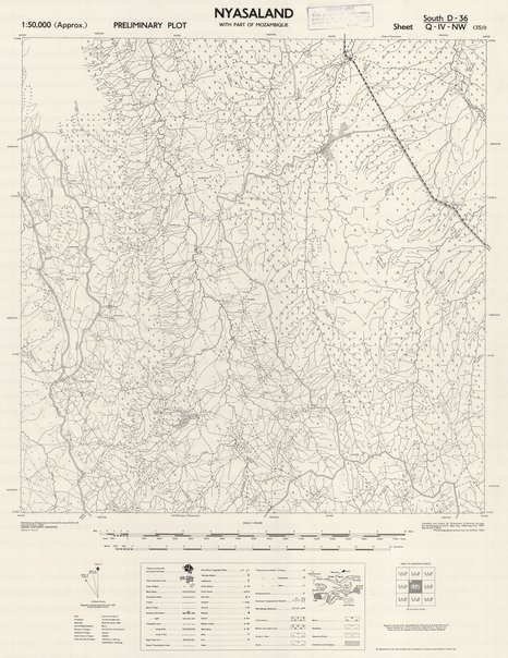
Preliminary plot Nyasaland with part of mozambique, sheet south D-36/Q-IV-NW (135/I)
Cette carte localise les infrastructures, les routes, les localités, les différentes forêts, les agglomérations dans une partie du Nord Ouest de Nyasaland vers les années 1954.
Simple
- Date (Publication)
- 1954-01-01
- Date (Creation)
- 1954-01-01
- Date (Revision)
- 1954-01-01
- Citation identifier
- CD-CRSN-DOC1191
Owner
Centre de Recherche en Sciences Naturelles (CRSN)
Lwiro
,
Bukavu
,
00000
,
République Démocratique du Congo
-
None
-
-
nyasaland
-
-
None
-
-
malawi
-
-
None
-
-
mozambique
-
-
GEMET - INSPIRE Themes
-
-
Altitude
-
-
GEMET - INSPIRE Themes
-
-
Occupation des terres
-
-
GEMET - INSPIRE Themes
-
-
Bâtiments
-
- Use limitation
-
None
- Access constraints
- Other restrictions
- Other constraints
-
Pas de restriction d'accès public selon INSPIRE
- Denominator
- 50000
- Language
- English
- Character set
- MD_CharacterSetCode_utf8
- Topic category
-
- Elevation
- Imagery base maps earth cover
- Structure
- Description
-
Liste des emprises
N
S
E
W
))
- Reference system identifier
- EPSG / urn:ogc:def:crs:EPSG:6.11:4258
- Distribution format
-
-
JPEG JFIF
(
None
)
-
JPEG JFIF
(
None
)
- Protocol
-
http
- Name of the resource
-
Centre de Recherche en Sciences Naturelles (CRSN) Lwiro
- Hierarchy level
- Dataset
Conformance result
- Date (Creation)
- 2010-11-23
- Explanation
-
See the referenced specification
- Pass
- Yes
- Statement
-
Compiled and drawn by Directorate of Colonial Surveys. Air photography by R.A.F., May-Aug. 1948, Aug.-Nov. 1951. May and June 1952. Photolithographed and printed by G.S.G.S., 1954.
- File identifier
- CD-CRSN-DOC1191 XML
- Metadata language
- Français
- Character set
- MD_CharacterSetCode_utf8
- Hierarchy level
- Dataset
- Date stamp
- 2017-11-06
- Metadata standard name
-
ISO19115
- Metadata standard version
-
2003/Cor.1:2006
Point of contact
Centre de Recherche en Sciences Naturelles (CRSN)
Lwiro
,
Bukavu
,
00000
,
République Démocratique du Congo
Overviews
Spatial extent
N
S
E
W
Provided by

Associated resources
Not available