 Geocatalogue of the Royal Museum for Central Africa
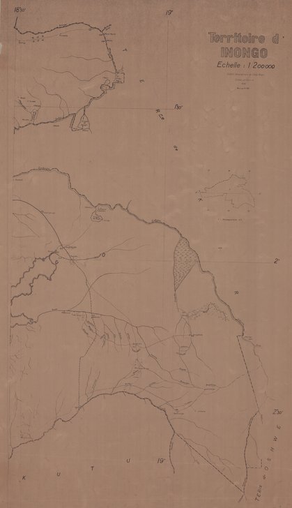
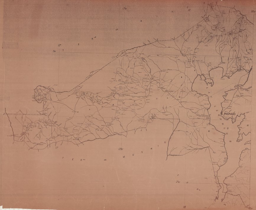
Carte du territoire de Inongo en République Démocratique du Congo (RDC) 1956
Cette carte montre les limites du territoire de Inongo en République Démocratique du Congo. Elle localise aussi les entités administratives (Chef-lieu...), les principales routes, les rivières, les territoires voisins...
Simple
- Date (Publication)
- 1956-01-01
- Date (Creation)
- 2020-01-01
- Date (Revision)
- 2020-01-01
- Citation identifier
- CD-CRSN-DOC146
Owner
Centre de Recherche en Sciences Naturelles (CRSN) Lwiro
Lwiro
,
Bukavu
,
00000
,
Belgique
None
-
GEMET - INSPIRE Themes
-
-
rdc
-
- Keywords
-
-
territoire
-
- Keywords
-
-
inongo
-
-
GEMET - INSPIRE Themes
-
-
Unités administratives
-
- Access constraints
- Other restrictions
- Other constraints
-
Pas de restriction d'accès public selon INSPIRE
- Denominator
- 200000
- Language
- Français
- Topic category
-
- Boundaries
- Description
-
Liste des emprises
N
S
E
W
))
- Reference system identifier
- urn:ogc:def:crs:EPSG:6.11 / 4258 / 6.11
- Distribution format
-
-
GeoTIFF
(
None
)
-
GeoTIFF
(
None
)
- Name of the resource
-
Centre de Recherche en Sciences Naturelles (CRSN) Lwiro
- Hierarchy level
- Dataset
Conformance result
- Date (Creation)
- 2010-11-23
- Explanation
-
See the referenced specification
- Pass
- Yes
- Statement
-
Insitut Géographique du Congo Belge en 1956
- File identifier
- CD-CRSN-DOC146 XML
- Metadata language
- Français
- Character set
- MD_CharacterSetCode_utf8
- Hierarchy level
- Dataset
- Date stamp
- 2020-08-18
- Metadata standard name
-
ISO19115
- Metadata standard version
-
2003/Cor.1:2006
Point of contact
Centre de Recherche en Sciences Naturelles (CRSN) Lwiro
Lwiro
,
Bukavu
,
00000
,
Belgique
None
Overviews
Spatial extent
N
S
E
W
Provided by

Associated resources
Not available