 Geocatalogue of the Royal Museum for Central Africa
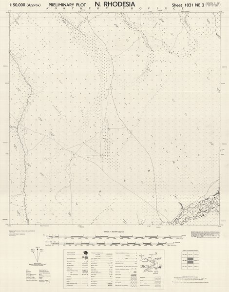
Map of Northern Rhodesia, sheet 1031 NE3 South C-36-N-II-SW, 1952
Cette carte informe sur les aspects relatifs à l'agglomération et communication d'une entité située dans la partie nord de Rhodesie vers les années 1952.
Simple
- Date (Publication)
- 1952-01-01
- Date (Creation)
- 1952-01-01
- Date (Revision)
- 1952-01-01
- Citation identifier
- CD-CRSN-DOC1709
-
-
rhodesia
-
-
-
localisation
-
-
-
structure
-
-
GEMET - INSPIRE Themes
-
-
Adresses
-
-
GEMET - INSPIRE Themes
-
-
Réseaux de transport
-
-
GEMET - INSPIRE Themes
-
-
Dénominations géographiques
-
- Use limitation
-
None
- Access constraints
- Other restrictions
- Other constraints
-
Pas de restriction d'accès public selon INSPIRE
- Denominator
- 50000
- Language
- English
- Topic category
-
- Location
- Location
- Transportation
- Description
-
Liste des emprises
))
- Reference system identifier
- urn:ogc:def:crs:EPSG:6.11 / 4258 / 6.11
- Distribution format
-
-
GeoTIFF
(
None
)
-
GeoTIFF
(
None
)
- Name of the resource
-
Centre de Recherche en Sciences Naturelles (CRSN) Lwiro
- Hierarchy level
- Dataset
Conformance result
- Date (Creation)
- 2010-11-23
- Explanation
-
See the referenced specification
- Pass
- Yes
- Statement
-
Compiled and drawn by Directorate of Colonial Surveys. Partly controlled by contrl supplied, by Directorate of colonial surveys, by points identified at Directorate of colonial surveys and by Radar Tracks from Mbeya Radar Station.
Air photography by R.A.F. May, June and July 1948. June and July 1950.
Photolithographed and printed by G.S.G.S. 1952
- File identifier
- CD-CRSN-DOC1709 XML
- Metadata language
- Français
- Character set
- MD_CharacterSetCode_utf8
- Hierarchy level
- Dataset
- Date stamp
- 2018-05-15
- Metadata standard name
-
ISO19115
- Metadata standard version
-
2003/Cor.1:2006
Overviews
Spatial extent
Provided by
