 Geocatalogue of the Royal Museum for Central Africa
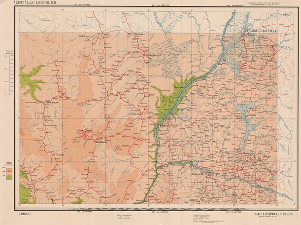
Carte du Lac Léopold II en République Démocratique du Congo, 1950
Cette carte livre les informations topographiques sur le Lac Léopold II (Actuel Lac Mai-ndombe) et ses environs en République Démocratique du Congo vers les années 1950.
Simple
- Date (Publication)
- 1956-01-01
- Date (Creation)
- 1956-01-01
- Date (Revision)
- 1956-01-01
- Citation identifier
- CD-CRSN-DOC1737
Owner
Centre de Recherche en Sciences Naturelles (CRSN) Lwiro
Lwiro
,
Bukavu
,
00000
,
République Démocratique du Congo
None
-
-
monde
-
-
-
rdc
-
-
-
lac léopold II
-
-
-
topographie
-
-
GEMET - INSPIRE Themes
-
-
Adresses
-
-
GEMET - INSPIRE Themes
-
-
Hydrographie
-
-
GEMET - INSPIRE Themes
-
-
Dénominations géographiques
-
- Use limitation
-
None
- Access constraints
- Other restrictions
- Other constraints
-
Pas de restriction d'accès public selon INSPIRE
- Denominator
- 0
- Language
- Français
- Topic category
-
- Location
- Location
- Inland waters
- Description
-
Liste des emprises
N
S
E
W
))
- Reference system identifier
- urn:ogc:def:crs:EPSG:6.11 / 4258 / 6.11
- Distribution format
-
-
GeoTIFF
(
None
)
-
GeoTIFF
(
None
)
- Name of the resource
-
Centre de Recherche en Sciences Naturelles (CRSN) Lwiro
- Hierarchy level
- Dataset
Conformance result
- Date (Creation)
- 2010-11-23
- Explanation
-
See the referenced specification
- Pass
- Yes
- Statement
-
La compulalation ainsi que la publication sont l'oeuvre de l'Institut Géographique du Congo en 1950.
- File identifier
- CD-CRSN-DOC1737 XML
- Metadata language
- Français
- Character set
- MD_CharacterSetCode_utf8
- Hierarchy level
- Dataset
- Date stamp
- 2018-05-17
- Metadata standard name
-
ISO19115
- Metadata standard version
-
2003/Cor.1:2006
Point of contact
Centre de Recherche en Sciences Naturelles (CRSN) Lwiro
Lwiro
,
Bukavu
,
00000
,
République Démocratique du Congo
None
Overviews
Spatial extent
N
S
E
W
Provided by

Associated resources
Not available