 Geocatalogue of the Royal Museum for Central Africa
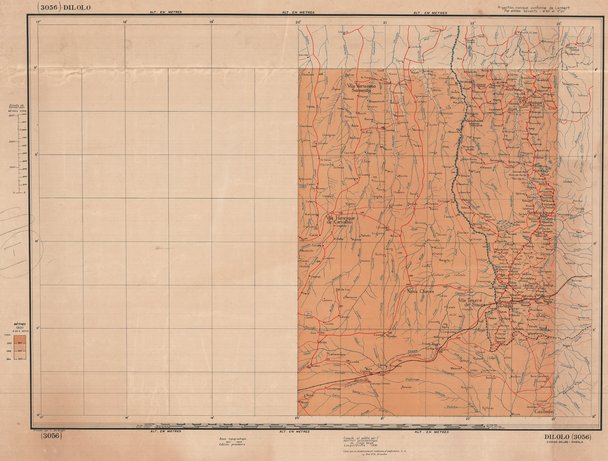
Carte de la République Démocratique du Congo, Dilolo (1950)
Cette carte rensigne concernant les aspects topographique de Dilolo une entité de la République Démocratique du Congo vers les années 1950.
Simple
- Date (Publication)
- 1950-01-01
- Date (Creation)
- 1950-01-01
- Date (Revision)
- 1950-01-01
- Citation identifier
- CD-CRSN-DOC1746
Owner
Centre de Recherche en Sciences Naturelles (CRSN) Lwiro
Lwiro
,
Bukavu
,
00000
,
République Démocratique du Congo
None
-
-
rdc
-
-
-
localisation
-
-
-
eaux intérieures
-
-
-
route
-
-
GEMET - INSPIRE Themes
-
-
Hydrographie
-
-
GEMET - INSPIRE Themes
-
-
Occupation des terres
-
- Use limitation
-
None
- Access constraints
- Other restrictions
- Other constraints
-
Pas de restriction d'accès public selon INSPIRE
- Denominator
- 5000000
- Language
- Français
- Topic category
-
- Inland waters
- Imagery base maps earth cover
- Description
-
Liste des emprises
N
S
E
W
))
- Reference system identifier
- urn:ogc:def:crs:EPSG:6.11 / 4258 / 6.11
- Distribution format
-
-
GeoTIFF
(
None
)
-
GeoTIFF
(
None
)
- Name of the resource
-
Centre de Recherche en Sciences Naturelles (CRSN) Lwiro
- Hierarchy level
- Dataset
Conformance result
- Date (Creation)
- 2010-11-23
- Explanation
-
See the referenced specification
- Pass
- Yes
- Statement
-
Cette carte a été compilée puis publiée par l'Institut Géographique du Congo (Léopoldville) en 1950.
- File identifier
- CD-CRSN-DOC1746 XML
- Metadata language
- Français
- Character set
- MD_CharacterSetCode_utf8
- Hierarchy level
- Dataset
- Date stamp
- 2018-06-08
- Metadata standard name
-
ISO19115
- Metadata standard version
-
2003/Cor.1:2006
Point of contact
Centre de Recherche en Sciences Naturelles (CRSN) Lwiro
Lwiro
,
Bukavu
,
00000
,
République Démocratique du Congo
None
Overviews
Spatial extent
N
S
E
W
Provided by

Associated resources
Not available