 Geocatalogue of the Royal Museum for Central Africa
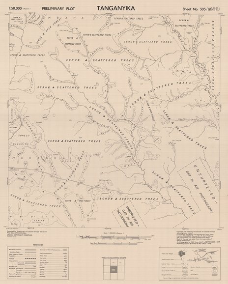
Tanganyika Sheet N°303-IV-SC-37-N-IV-SE, 1948
Cette carte indique l'hydrographie, les zones forestières, les plantations et les fermes de la partie Sud-Ouest de la Tanzanie.
Simple
- Date (Publication)
- 1948-01-01
- Date (Creation)
- 1947-09-01
- Date (Revision)
- 1948-01-01
- Citation identifier
- CD-CRSN-DOC1808
-
-
tanganyika
-
-
-
tanzanie
-
-
-
hydrographie
-
-
-
parc national albert
-
-
GEMET - INSPIRE Themes
-
-
Dénominations géographiques
-
-
GEMET - INSPIRE Themes
-
-
Hydrographie
-
-
GEMET - INSPIRE Themes
-
-
Occupation des terres
-
-
GEMET - INSPIRE Themes
-
-
Geographical names
-
-
GEMET - INSPIRE Themes
-
-
Hydrography
-
-
GEMET - INSPIRE Themes
-
-
Land cover
-
- Use limitation
-
None
- Access constraints
- Other restrictions
- Other constraints
-
No restriction for public access with INSPIRE
- Denominator
- 50000
- Language
- English
- Topic category
-
- Location
- Inland waters
- Imagery base maps earth cover
- Description
-
Liste des emprises
))
- Reference system identifier
- urn:ogc:def:crs:EPSG:6.11 / 4258 / 6.11
- Distribution format
-
-
GeoTIFF
(
None
)
-
GeoTIFF
(
None
)
- Name of the resource
-
Centre de Recherche en Sciences Naturelles (CRSN) Lwiro
- Hierarchy level
- Dataset
Conformance result
- Date (Creation)
- 2010-11-23
- Explanation
-
See the referenced specification
- Pass
- Yes
- Statement
-
Compiled and drown by Directorate of Colonial Survesurvys without ground control.
Approximate scale and azimuth obtainded from co-ordinates of Tunduru, tajen from the 1:500,000 Tunduru E.A.F. 655 map and radar tracks computed from Lindi Radar Station.
Air photography by R.A.F. from July to September 1947.
Photoligraphed & Printed at War Office, 1948
- File identifier
- CD-CRSN-DOC1808 XML
- Metadata language
- Français
- Character set
- MD_CharacterSetCode_utf8
- Hierarchy level
- Dataset
- Date stamp
- 2019-02-11
- Metadata standard name
-
ISO19115
- Metadata standard version
-
2003/Cor.1:2006
Overviews
Spatial extent
Provided by
