 Geocatalogue of the Royal Museum for Central Africa
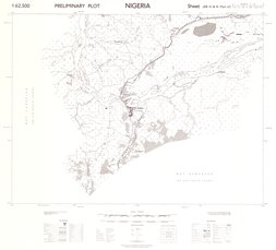
Nigeria Preliminary plot, Sheet JEB IV & III (Part of) (NORTH C-31/Q-IV-SE & SW part of, 1950
Cette carte indique l'hydrographie, les agglomérations, les habitations, la végétation et les voies de communication d'une entité du Nigeria.
Simple
- Date (Publication)
- 1950-01-12
- Date (Creation)
- 1950-01-01
- Date (Revision)
- 1950-01-01
- Citation identifier
- CD-CRSN-DOC1902
-
-
nigeria
-
-
-
structure
-
-
-
végétation
-
-
GEMET - INSPIRE Themes
-
-
Adresses
-
-
GEMET - INSPIRE Themes
-
-
Hydrographie
-
-
GEMET - INSPIRE Themes
-
-
Unités statistiques
-
-
GEMET - INSPIRE Themes
-
-
Bâtiments
-
-
GEMET - INSPIRE Themes
-
-
Usage des sols
-
- Use limitation
-
None
- Access constraints
- Other restrictions
- Other constraints
-
Pas de restriction d'accès public selon INSPIRE
- Denominator
- 62500
- Language
- Français
- Topic category
-
- Location
- Inland waters
- Boundaries
- Structure
- Planning cadastre
- Description
-
Liste des emprises
))
- Reference system identifier
- urn:ogc:def:crs:EPSG:6.11 / 4258 / 6.11
- Distribution format
-
-
GeoTIFF
(
None
)
-
GeoTIFF
(
None
)
- Name of the resource
-
Centre de Recherche en Sciences Naturelles (CRSN) Lwiro
- Hierarchy level
- Dataset
Conformance result
- Date (Creation)
- 2010-11-23
- Explanation
-
See the referenced specification
- Pass
- Yes
- Statement
-
Compiled and drawn by Directorate of Surveys from control by Survey Departement Nigeria.
Air photography by R.A.F. NOov. 1948to Jan. 1949.
Photolithographed and printed by G.S.G.S. 1950.
- File identifier
- CD-CRSN-DOC1902 XML
- Metadata language
- Français
- Character set
- MD_CharacterSetCode_utf8
- Hierarchy level
- Dataset
- Date stamp
- 2019-04-12
- Metadata standard name
-
ISO19115
- Metadata standard version
-
2003/Cor.1:2006
Overviews
Spatial extent
Provided by
