 Geocatalogue of the Royal Museum for Central Africa
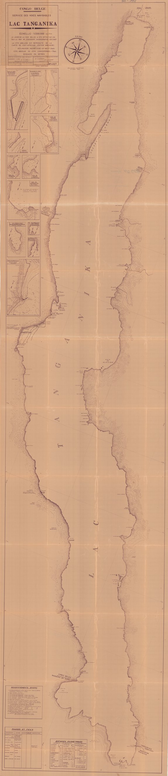
Carte du Lac Tanganyika, République démocratique du Congo 1940
Cette carte livre les informations relatives au Lac Tanganyika vers les années 1940.
Simple
- Date (Publication)
- 1940-01-01
- Date (Creation)
- 1940-01-01
- Date (Revision)
- 1940-01-08
- Citation identifier
- CD-CRSN-DOC1997
-
-
rdc
-
-
-
lac tanganyika
-
-
-
eaux intérieures
-
-
GEMET - INSPIRE Themes
-
-
Hydrographie
-
-
GEMET - INSPIRE Themes
-
-
Hydrography
-
- Use limitation
-
None
- Access constraints
- Other restrictions
- Other constraints
-
No restriction for public access with INSPIRE
- Denominator
- 200000
- Language
- Français
- Topic category
-
- Inland waters
- Description
-
Liste des emprises
N
S
E
W
))
- Reference system identifier
- urn:ogc:def:crs:EPSG:6.11 / 4258 / 6.11
- Distribution format
-
-
GeoTIFF
(
None
)
-
GeoTIFF
(
None
)
- Name of the resource
-
Centre de Recherche en Sciences Naturelles (CRSN) Lwiro
- Hierarchy level
- Dataset
Conformance result
- Date (Creation)
- 2010-11-23
- Explanation
-
See the referenced specification
- Pass
- Yes
- Statement
-
Direction du service des voies navigables en 1940.
- File identifier
- CD-CRSN-DOC1997 XML
- Metadata language
- Français
- Character set
- MD_CharacterSetCode_utf8
- Hierarchy level
- Dataset
- Date stamp
- 2018-06-30
- Metadata standard name
-
ISO19115
- Metadata standard version
-
2003/Cor.1:2006
Point of contact
Centre de Recherche en Sciences Naturelles (CRSN) Lwiro
Lwiro
,
Bukavu
,
00000
,
Belgium
None
Overviews
Spatial extent
N
S
E
W
Provided by

Associated resources
Not available