 Geocatalogue of the Royal Museum for Central Africa
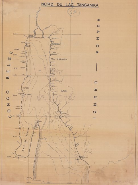
Carte du nord Lac Tanganyika, République Démocratique du Congo
Cette carte indique l’hydrographie et les localités du bassin Nord du Lac Tanganyika.
Simple
- Date (Creation)
- 1947-01-01
- Date (Revision)
- 1947-01-01
- Citation identifier
- CD-CRSN-DOC2021
-
-
rdc
-
-
-
lac tanganyika
-
-
-
eaux intérieures
-
-
GEMET - INSPIRE Themes
-
-
hydrographie
-
-
GEMET - INSPIRE Themes
-
-
géologie
-
-
GEMET - INSPIRE Themes
-
-
Hydrography
-
-
GEMET - INSPIRE Themes
-
-
Geology
-
- Use limitation
-
None
- Access constraints
- Other restrictions
- Other constraints
-
No restriction for public access with INSPIRE
- Denominator
- 200000
- Language
- Français
- Topic category
-
- Inland waters
- Geoscientific information
- Description
-
Liste des emprises
N
S
E
W
))
- Reference system identifier
- urn:ogc:def:crs:EPSG:6.11 / 4258 / 6.11
- Distribution format
-
-
GeoTIFF
(
None
)
-
GeoTIFF
(
None
)
- Name of the resource
-
Centre de Recherches en Sciences Naturelles (CRSN) Lwiro
- Hierarchy level
- Dataset
Conformance result
- Date (Creation)
- 2010-11-23
- Explanation
-
See the referenced specification
- Pass
- Yes
- Statement
-
Sans édition, ni date
- File identifier
- CD-CRSN-DOC2021 XML
- Metadata language
- Français
- Character set
- MD_CharacterSetCode_utf8
- Hierarchy level
- Dataset
- Date stamp
- 2018-12-20
- Metadata standard name
-
ISO19115
- Metadata standard version
-
2003/Cor.1:2006
Point of contact
Centre de Recherche en Sciences Naturelles (CRSN) Lwiro
Lwiro
,
Bukavu
,
00000
,
Belgium
None
Overviews
Spatial extent
N
S
E
W
Provided by

Associated resources
Not available