 Geocatalogue of the Royal Museum for Central Africa
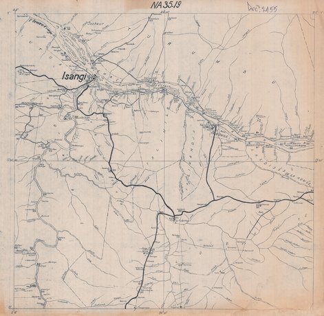
Carte de la ville de Isangi, République Démocratique du Congo (RDC)
Cette carte de la ville de Isangi (NA35.19) en République Démocratique du Congo. Elle délimite cette entité mais aussi elle montre l'hydrographie, les routes, les principaux centres, les lacs et parc etc..
Simple
- Date (Creation)
- 1959-01-01
- Date (Revision)
- 1959-01-01
- Citation identifier
- CD-CRSN-DOC2155
-
GEMET - INSPIRE Themes
-
-
rdc
-
-
GEMET - INSPIRE Themes
-
-
isangi
-
-
GEMET - INSPIRE Themes
-
-
ville
-
-
GEMET - INSPIRE Themes
-
-
unités administratives
-
-
GEMET - INSPIRE Themes
-
-
occupation des terres
-
-
GEMET - INSPIRE Themes
-
-
Administrative Units
-
-
GEMET - INSPIRE Themes
-
-
Land cover
-
- Access constraints
- Other restrictions
- Other constraints
-
No restriction for public access with INSPIRE
- Denominator
- 0
- Language
- Français
- Topic category
-
- Boundaries
- Imagery base maps earth cover
- Description
-
Liste des emprises
N
S
E
W
))
- Reference system identifier
- urn:ogc:def:crs:EPSG:6.11 / 4210 / 6.11
- Distribution format
-
-
GEO TIFF
(
None
)
-
GEO TIFF
(
None
)
- Name of the resource
-
Centre de Recherche en Sciences Naturelles (CRSN) Lwiro
- Hierarchy level
- Dataset
Conformance result
- Date (Creation)
- 2010-11-23
- Explanation
-
See the referenced specification
- Pass
- Yes
- Statement
-
Sans date, ni éditon.
- File identifier
- CD-CRSN-DOC2155 XML
- Metadata language
- Français
- Character set
- MD_CharacterSetCode_utf8
- Hierarchy level
- Dataset
- Date stamp
- 2020-08-14
- Metadata standard name
-
ISO19115
- Metadata standard version
-
2003/Cor.1:2006
Point of contact
Centre de Recherche en Sciences Naturelles (CRSN) Lwiro
Lwiro
,
Bukavu
,
00000
,
Belgium
None
Overviews
Spatial extent
N
S
E
W
Provided by

Associated resources
Not available