 Geocatalogue of the Royal Museum for Central Africa
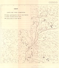
Carte des types d'habitation au Congo (Occidental)
Cette carte indique l'hydrographie et les informations relatives aux types d'habitations (cases quadrangulaires, circulaires, toit et mur dans la partie occidentale de la République Démocratique du Congo.
Simple
- Date (Creation)
- 1973-04-01
- Date (Revision)
- 1973-04-01
- Citation identifier
- CD-CRSN-DOC2180
Owner
Centre de Recherche en Sciences Naturelles (CRSN) Lwiro
Lwiro
,
Bukavu
,
00000
,
République démocratique du Congo
-
-
rdc
-
-
-
occidental
-
-
-
case
-
-
GEMET - INSPIRE Themes
-
-
Hydrographie
-
-
GEMET - INSPIRE Themes
-
-
Sites protégés
-
-
GEMET - INSPIRE Themes
-
-
Occupation des terres
-
-
GEMET - INSPIRE Themes
-
-
Sols
-
- Use limitation
-
None
- Access constraints
- Other restrictions
- Other constraints
-
Pas de restriction d'accès public selon INSPIRE
- Denominator
- 2000000
- Language
- Français
- Topic category
-
- Inland waters
- environnement
- Imagery base maps earth cover
- Geoscientific information
- Description
-
Liste des emprises
N
S
E
W
))
- Reference system identifier
- urn:ogc:def:crs:EPSG:6.11 / 4258 / 6.11
- Distribution format
-
-
GeoTIFF
(
None
)
-
GeoTIFF
(
None
)
- Name of the resource
-
Centre de Recherche en Sciences Naturelles (CRSN) Lwiro
- Hierarchy level
- Dataset
Conformance result
- Date (Creation)
- 2010-11-23
- Explanation
-
See the referenced specification
- Pass
- Yes
- Statement
-
Sans édtion, sans date.
- File identifier
- CD-CRSN-DOC2180 XML
- Metadata language
- Français
- Character set
- MD_CharacterSetCode_utf8
- Hierarchy level
- Dataset
- Date stamp
- 2019-04-19
- Metadata standard name
-
ISO19115
- Metadata standard version
-
2003/Cor.1:2006
Point of contact
Centre de Recherche en Sciences Naturelles (CRSN) Lwiro
Lwiro
,
Bukavu
,
00000
,
République démocratique du Congo
Overviews
Spatial extent
N
S
E
W
Provided by

Associated resources
Not available