 Geocatalogue of the Royal Museum for Central Africa
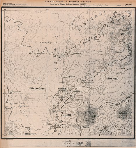
Carte de la région du parc national Albert, 1948
Cette carte indique les territoires, les localités, les courbes, les marais, l'hydrographie et les voies de communication d'une partie du Parc National Albert (Virunga: Kisagari, RutareKanamahagare, Rugari, Kibumba, Mashayi, Gashole...) en République Démocratique du Congo.
Simple
- Date (Publication)
- 1948-01-01
- Date (Creation)
- 1948-01-01
- Date (Revision)
- 1948-01-01
- Citation identifier
- CD-CRSN-DOC2236
-
-
rdc
-
-
-
parc national des virunga
-
-
-
localisation
-
-
-
parc national albert
-
-
-
localisation
-
-
-
structure
-
-
GEMET - INSPIRE Themes
-
-
Unités administratives
-
-
GEMET - INSPIRE Themes
-
-
Adresses
-
-
GEMET - INSPIRE Themes
-
-
Hydrographie
-
-
GEMET - INSPIRE Themes
-
-
Occupation des terres
-
- Use limitation
-
None
- Access constraints
- Other restrictions
- Other constraints
-
Pas de restriction d'accès public selon INSPIRE
- Denominator
- 50000
- Language
- Français
- Topic category
-
- Boundaries
- Location
- Inland waters
- Imagery base maps earth cover
- Description
-
Liste des emprises
))
- Reference system identifier
- urn:ogc:def:crs:EPSG:6.11 / 4258 / 6.11
- Distribution format
-
-
GeoTIFF
(
None
)
-
GeoTIFF
(
None
)
- Name of the resource
-
Centre de Recherche en Sciences Naturelles (CRSN) Lwiro
- Hierarchy level
- Dataset
Conformance result
- Date (Creation)
- 2010-11-23
- Explanation
-
See the referenced specification
- Pass
- Yes
- Statement
-
Institut Géographique du Congo Belge, 1948.
- File identifier
- CD-CRSN-DOC2236 XML
- Metadata language
- Français
- Character set
- MD_CharacterSetCode_utf8
- Hierarchy level
- Dataset
- Date stamp
- 2019-02-18
- Metadata standard name
-
ISO19115
- Metadata standard version
-
2003/Cor.1:2006
Overviews
Spatial extent
Provided by
