 Geocatalogue of the Royal Museum for Central Africa
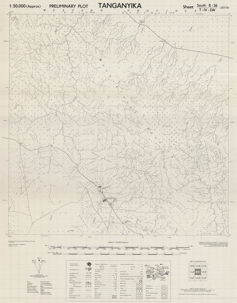
Tanganyika preliminary plot sheet south-SB36-T-IV-SW (207-III), 1953
Cette carte indique les agglomérations, l'hydrographie, la végétations, les installations publiques ainsi que privées et les voies de communication dans une partie du Sud de Tanganyika en Tanzanie.
Simple
- Date (Publication)
- 1953-01-01
- Date (Creation)
- 1953-01-01
- Date (Revision)
- 1953-01-01
- Citation identifier
- CD-CRSN-DOC2268
-
-
tanganyika
-
-
-
tanzania
-
-
-
localisation
-
-
-
structure
-
-
GEMET - INSPIRE Themes
-
-
Unités administratives
-
-
GEMET - INSPIRE Themes
-
-
Adresses
-
-
GEMET - INSPIRE Themes
-
-
Hydrographie
-
-
GEMET - INSPIRE Themes
-
-
Unités statistiques
-
-
GEMET - INSPIRE Themes
-
-
Bâtiments
-
- Use limitation
-
None
- Access constraints
- Other restrictions
- Other constraints
-
Pas de restriction d'accès public selon INSPIRE
- Denominator
- 50000
- Language
- English
- Topic category
-
- Boundaries
- Location
- Inland waters
- Boundaries
- Structure
- Description
-
Liste des emprises
))
- Reference system identifier
- urn:ogc:def:crs:EPSG:6.11 / 4258 / 6.11
- Distribution format
-
-
GeoTIFF
(
None
)
-
GeoTIFF
(
None
)
- Name of the resource
-
Centre de Recherche en Sciences Naturelles (CRSN) Lwiro
- Hierarchy level
- Dataset
Conformance result
- Date (Creation)
- 2010-11-23
- Explanation
-
See the referenced specification
- Pass
- Yes
- Statement
-
Compiled and drawn by Directorate of Colonial Surveys with control (unidentified) supplied by Tanganyika Lands and Surveys Department, also Radar Tracks computed from Mbeya.
Air photography by R.AF. June 1950.
Photolithographed and printed by G.S.G.S., 1953.
- File identifier
- CD-CRSN-DOC2268 XML
- Metadata language
- Français
- Character set
- MD_CharacterSetCode_utf8
- Hierarchy level
- Dataset
- Date stamp
- 2019-03-15
- Metadata standard name
-
ISO19115
- Metadata standard version
-
2003/Cor.1:2006
Overviews
Spatial extent
Provided by
