 Geocatalogue of the Royal Museum for Central Africa
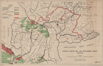
Central African rail link developement survey political. (Rhodesie-Tanzania), Map Nº3, 1952
Cette carte indique l'hydrographie, les fôrets, les réserves, les voies de communication et les limites de la Rhodesie du Sud, de l'Est Africain Portugaise, de Tanganyika et de Nyasaland.
Simple
- Date (Publication)
- 1952-01-01
- Date (Creation)
- 1952-01-01
- Date (Revision)
- 1952-01-01
- Citation identifier
- CD-CRSN-DOC2300
-
-
tanzania
-
-
-
tanganyika
-
-
-
rhodesie
-
-
-
afrique central
-
-
GEMET - INSPIRE Themes
-
-
sol
-
-
GEMET - INSPIRE Themes
-
-
Unités administratives
-
-
GEMET - INSPIRE Themes
-
-
Réseaux de transport
-
-
GEMET - INSPIRE Themes
-
-
Hydrographie
-
- Use limitation
-
None
- Access constraints
- Other restrictions
- Other constraints
-
Pas de restriction d'accès public selon INSPIRE
- Denominator
- 3000000
- Language
- English
- Topic category
-
- Boundaries
- Transportation
- Inland waters
- Description
-
Liste des emprises
))
- Reference system identifier
- urn:ogc:def:crs:EPSG:6.11 / 4258 / 6.11
- Distribution format
-
-
GeoTIFF
(
None
)
-
GeoTIFF
(
None
)
- Name of the resource
-
Centre de Recherche en Sciences Naturelles (CRSN) Lwiro
- Hierarchy level
- Dataset
Conformance result
- Date (Creation)
- 2010-11-23
- Explanation
-
See the referenced specification
- Pass
- Yes
- Statement
-
Drwan by Directorate of Colonial Surveys from information supplied by Sir Alexander Gibb & Parteners. Photolithographed & Printed by G.S.G.S. 1952.
- File identifier
- CD-CRSN-DOC2300 XML
- Metadata language
- Français
- Character set
- MD_CharacterSetCode_utf8
- Hierarchy level
- Dataset
- Date stamp
- 2019-03-29
- Metadata standard name
-
ISO19115
- Metadata standard version
-
2003/Cor.1:2006
Overviews
Spatial extent
Provided by
