 Geocatalogue of the Royal Museum for Central Africa
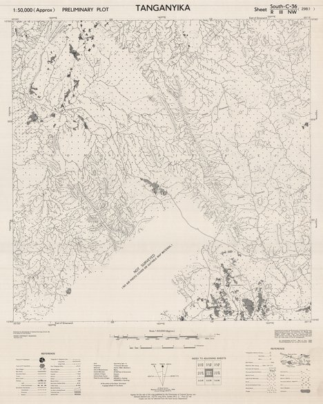
Tanganyika (preliminary plot) sheet south-C-36-R-III-NW 298-I, 1950
Cette carte indique l'hydrographie, les agglomérations, les voies de communication...d'une entité au Nord-ouest de Tanganyika en Tanzanie
Simple
- Date (Publication)
- 1950-01-01
- Date (Creation)
- 1950-01-01
- Date (Revision)
- 1950-01-01
- Citation identifier
- CD-CRSN-DOC2328
-
-
tanganyika
-
-
-
tanzanie
-
-
-
localisation
-
-
-
structure
-
-
-
limite
-
-
GEMET - INSPIRE Themes
-
-
Adresses
-
-
GEMET - INSPIRE Themes
-
-
Réseaux de transport
-
-
GEMET - INSPIRE Themes
-
-
Hydrographie
-
-
GEMET - INSPIRE Themes
-
-
Occupation des terres
-
- Use limitation
-
None
- Access constraints
- Other restrictions
- Other constraints
-
Pas de restriction d'accès public selon INSPIRE
- Denominator
- 50000
- Language
- English
- Topic category
-
- Location
- Transportation
- Inland waters
- Imagery base maps earth cover
- Description
-
Liste des emprises
))
- Reference system identifier
- urn:ogc:def:crs:EPSG:6.11 / 4258 / 6.11
- Distribution format
-
-
GeoTIFF
(
None
)
-
GeoTIFF
(
None
)
- Name of the resource
-
Centre de Recherche en Sciences Naturelles (CRSN) Lwiro
- Hierarchy level
- Dataset
Conformance result
- Date (Creation)
- 2010-11-23
- Explanation
-
See the referenced specification
- Pass
- Yes
- Statement
-
Compiled and darwn by Directorate of Colonial Surveys without ground. Co-ordinates for Manda and Magazini. Mission have been taken from Songea the 1:500,000 Ruvumba E.A.F. 1995 map and approximate true north oriented from these. Scale of this map was taken from the mean scale of the air photographs.
Air photography by R.A.F. from May to July 1948.
Photolithographed and printed at G.S.G.S. 1950.
- File identifier
- CD-CRSN-DOC2328 XML
- Metadata language
- Français
- Character set
- MD_CharacterSetCode_utf8
- Hierarchy level
- Dataset
- Date stamp
- 2019-03-29
- Metadata standard name
-
ISO19115
- Metadata standard version
-
2003/Cor.1:2006
Overviews
Spatial extent
Provided by
