 Geocatalogue of the Royal Museum for Central Africa
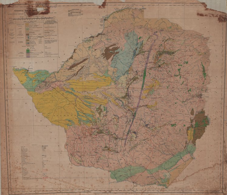
Geological Map of South Rhodesia and Tati Concession, 1946
Cette carte indique les aspects géologiques, l'hdrographie, les infrastrutures, les agglomérations et les voies de communication d'une partie de la Rhodesie du Sud.
Simple
- Date (Publication)
- 1946-01-01
- Date (Creation)
- 1946-01-01
- Date (Revision)
- 1946-01-01
- Citation identifier
- CD-CRSN-DOC2356
-
-
zimbabwe
-
-
-
rhodesie
-
-
-
structure
-
-
-
géologie
-
-
GEMET - INSPIRE Themes
-
-
Unités administratives
-
-
GEMET - INSPIRE Themes
-
-
Adresses
-
-
GEMET - INSPIRE Themes
-
-
Hydrographie
-
-
GEMET - INSPIRE Themes
-
-
Géologie
-
-
GEMET - INSPIRE Themes
-
-
Unités statistiques
-
-
GEMET - INSPIRE Themes
-
-
Bâtiments
-
-
GEMET - INSPIRE Themes
-
-
Sols
-
- Use limitation
-
None
- Access constraints
- Other restrictions
- Other constraints
-
Pas de restriction d'accès public selon INSPIRE
- Denominator
- 1000000
- Language
- English
- Topic category
-
- Boundaries
- Location
- Inland waters
- Geoscientific information
- Boundaries
- Structure
- Geoscientific information
- Description
-
Liste des emprises
))
- Reference system identifier
- urn:ogc:def:crs:EPSG:6.11 / 4258 / 6.11
- Distribution format
-
-
GeoTIFF
(
None
)
-
GeoTIFF
(
None
)
- Name of the resource
-
Centre de Recherche en Sciences Naturelles (CRSN) Lwiro
- Hierarchy level
- Dataset
Conformance result
- Date (Creation)
- 2010-11-23
- Explanation
-
See the referenced specification
- Pass
- Yes
- Statement
-
Revised edition compiled in the geological survey office, Salisbury, S.R 1946.
- File identifier
- CD-CRSN-DOC2356 XML
- Metadata language
- Français
- Character set
- MD_CharacterSetCode_utf8
- Hierarchy level
- Dataset
- Date stamp
- 2019-04-05
- Metadata standard name
-
ISO19115
- Metadata standard version
-
2003/Cor.1:2006
Overviews
Spatial extent
Provided by
