 Geocatalogue of the Royal Museum for Central Africa
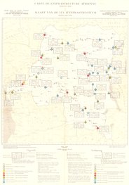
Carte de l'infrastructure aérienne en République Démocratique du Congo (RDC), 1956
Cette carte indique l'hydrographie, les aérodromes (civiles et militaires) pourvus d'un radiophare non directionnel ainsi que les pistes en République Démocratique du Congo.
Simple
- Date (Publication)
- 1956-01-11
- Date (Creation)
- 1956-01-01
- Date (Revision)
- 1956-01-01
- Citation identifier
- CD-CRSN-DOC2359
Owner
Centre de Recherche en Sciences Naturelles (CRSN) Lwiro
Lwiro
,
Bukavu
,
00000
,
République démocratique du Congo
-
-
rdc
-
-
-
structure
-
-
-
aviation
-
-
GEMET - INSPIRE Themes
-
-
Adresses
-
-
GEMET - INSPIRE Themes
-
-
Hydrographie
-
-
GEMET - INSPIRE Themes
-
-
Bâtiments
-
- Use limitation
-
None
- Access constraints
- Other restrictions
- Other constraints
-
Pas de restriction d'accès public selon INSPIRE
- Denominator
- 5000000
- Language
- Français
- Topic category
-
- Location
- Inland waters
- Structure
- Description
-
Liste des emprises
N
S
E
W
))
- Reference system identifier
- urn:ogc:def:crs:EPSG:6.11 / 4258 / 6.11
- Distribution format
-
-
GeoTIFF
(
None
)
-
GeoTIFF
(
None
)
- Name of the resource
-
Centre de Recherche en Sciences Naturelles (CRSN) Lwiro
- Hierarchy level
- Dataset
Conformance result
- Date (Creation)
- 2010-11-23
- Explanation
-
See the referenced specification
- Pass
- Yes
- Statement
-
Fond dressé par le service cartographique du Ministère des Colonies,1953.
Institut Géographique Militaire, Bruxelles, 1956.
- File identifier
- CD-CRSN-DOC2359 XML
- Metadata language
- Français
- Character set
- MD_CharacterSetCode_utf8
- Hierarchy level
- Dataset
- Date stamp
- 2019-04-12
- Metadata standard name
-
ISO19115
- Metadata standard version
-
2003/Cor.1:2006
Point of contact
Centre de Recherche en Sciences Naturelles (CRSN) Lwiro
Lwiro
,
Bukavu
,
00000
,
République démocratique du Congo
Overviews
Spatial extent
N
S
E
W
Provided by

Associated resources
Not available