 Geocatalogue of the Royal Museum for Central Africa
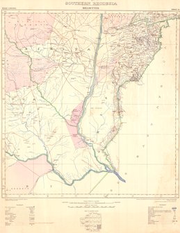
Southern Rhodesia Melsetter, 1947
Cette carte indique l'hydrographie, les villes, les fermes, le relief, les voies de communication (routes, aérodrome..) et les limites de Melsetter en Rhodesie du Sud.
Simple
- Date (Publication)
- 1947-01-01
- Date (Creation)
- 1947-01-01
- Date (Revision)
- 1947-01-01
- Citation identifier
- CD-CRSN-DOC2377
-
-
rhodesia
-
-
-
southern
-
-
-
melsetter
-
-
-
route
-
-
GEMET - INSPIRE Themes
-
-
Unités administratives
-
-
GEMET - INSPIRE Themes
-
-
Adresses
-
-
GEMET - INSPIRE Themes
-
-
Réseaux de transport
-
-
GEMET - INSPIRE Themes
-
-
Hydrographie
-
-
GEMET - INSPIRE Themes
-
-
Bâtiments
-
-
GEMET - INSPIRE Themes
-
-
Usage des sols
-
- Use limitation
-
None
- Access constraints
- Other restrictions
- Other constraints
-
Pas de restriction d'accès public selon INSPIRE
- Denominator
- 250000
- Language
- English
- Topic category
-
- Boundaries
- Location
- Transportation
- Inland waters
- Structure
- Planning cadastre
- Description
-
Liste des emprises
))
- Reference system identifier
- urn:ogc:def:crs:EPSG:6.11 / 4258 / 6.11
- Distribution format
-
-
GeoTIFF
(
None
)
-
GeoTIFF
(
None
)
- Name of the resource
-
Centre de Recherche en Sciences Naturelles (CRSN) Lwiro
- Hierarchy level
- Dataset
Conformance result
- Date (Creation)
- 2010-11-23
- Explanation
-
See the referenced specification
- Pass
- Yes
- Statement
-
Compiled and published by the Surveys General Departement, Salisbury, Southern Rhodesia, 1929.
Partially revised, 1947.
- File identifier
- CD-CRSN-DOC2377 XML
- Metadata language
- Français
- Character set
- MD_CharacterSetCode_utf8
- Hierarchy level
- Dataset
- Date stamp
- 2019-05-04
- Metadata standard name
-
ISO19115
- Metadata standard version
-
2003/Cor.1:2006
Overviews
Spatial extent
Provided by
