 Geocatalogue of the Royal Museum for Central Africa
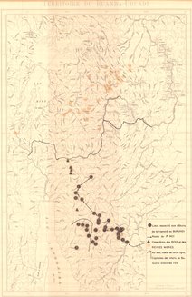
Territoire du Ruanda-Urundi, 1955
Cette carte indique l'hydrographie ainsi que les lieux associés au début de la royauté au Burundi, les routes du 1er Roi, les cimetières des Rois et des Reines Mères, au Sud-Ouest de cette ligne, les Capitales des Chefs du Butuutsi avant les Rois.
Simple
- Date (Publication)
- 1955-01-01
- Date (Creation)
- 1955-01-01
- Date (Revision)
- 1955-01-01
- Citation identifier
- CD-CRSN-DOC2436
-
-
ruanda
-
-
-
urundi
-
-
-
roi
-
-
-
reine
-
-
-
butuutsi
-
-
-
route
-
-
-
cimetière
-
-
GEMET - Concepts, version 2.4
-
-
accident
-
-
GEMET - INSPIRE Themes
-
-
Unités administratives
-
-
GEMET - INSPIRE Themes
-
-
Adresses
-
-
GEMET - INSPIRE Themes
-
-
Hydrographie
-
-
GEMET - INSPIRE Themes
-
-
Occupation des terres
-
-
GEMET - INSPIRE Themes
-
-
Bâtiments
-
-
GEMET - INSPIRE Themes
-
-
Répartition de la population - Démographie
-
- Use limitation
-
None
- Access constraints
- Other restrictions
- Other constraints
-
Pas de restriction d'accès public selon INSPIRE
- Denominator
- 500000
- Language
- Français
- Topic category
-
- Boundaries
- Location
- Inland waters
- Imagery base maps earth cover
- Structure
- Society
- Description
-
Liste des emprises
))
- Reference system identifier
- urn:ogc:def:crs:EPSG:6.11 / 4258 / 6.11
- Distribution format
-
-
GeoTIFF
(
None
)
-
GeoTIFF
(
None
)
- Name of the resource
-
Centre de Recherche en Sciences Naturelles (CRSN) Lwiro
- Hierarchy level
- Dataset
Conformance result
- Date (Creation)
- 2010-11-23
- Explanation
-
See the referenced specification
- Pass
- Yes
- Statement
-
Institut Géographique Militaire (IGM), 1955.
- File identifier
- CD-CRSN-DOC2436 XML
- Metadata language
- Français
- Character set
- MD_CharacterSetCode_utf8
- Hierarchy level
- Dataset
- Date stamp
- 2019-06-09
- Metadata standard name
-
ISO19115
- Metadata standard version
-
2003/Cor.1:2006
Overviews
Spatial extent
Provided by
