 Geocatalogue of the Royal Museum for Central Africa
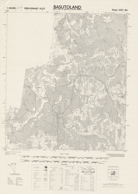
Basutoland : Preleminary Plot, Sheet 2927 BA with part of union of South Africa, 1953
This map is a visualization of populated areas and towns with perment buildings, villages, huts, main and secondary roads, track, kraals, railways (with station siding, light and under construction) boundaries (international, provincial and district) telegraph (telephone lines, along road and track), power transmission lines, post office, wireless and police station, coart and rest (hotel) house, P.W.D., barracks, hospital, church, school, mission, mosque, tample, rest camp, mine, ruins, mineral working, fort, trigonometrical cat (primary, secondary and minor station), boundary pillar, spot heights in feet well and spring, lave and crate, prominent hill features, bridge, ferry, dam, river or watercourse, waterfall, rapids, rocks, well, spring, waterhole, lava and crater, forest (dense, medium and light), distrct names, scrub and scattered trees (large and small), lake, swamps, mangrove, rice, palm, mango, nippa, bamboo, plantation and cultivation.
Simple
- Date (Publication)
- 1953-01-01
- Date (Creation)
- 1953-01-01
- Date (Revision)
- 1953-01-01
- Citation identifier
- CD-CRSN-DOC343
-
-
basutoland
-
-
-
south africa
-
-
-
boudaries
-
-
GEMET - INSPIRE Themes
-
-
Unités administratives
-
-
GEMET - INSPIRE Themes
-
-
Occupation des terres
-
- Access constraints
- Other restrictions
- Other constraints
-
Pas de restriction d'accès public selon INSPIRE
- Denominator
- 50000
- Language
- English
- Topic category
-
- Boundaries
- Imagery base maps earth cover
- Description
-
Liste des emprises
))
- Reference system identifier
- urn:ogc:def:crs:EPSG:6.11 / 4258 / 6.11
- Distribution format
-
-
JPEG JFIF
(
None
)
-
JPEG JFIF
(
None
)
- Name of the resource
-
Centre de Recherche en Sciences Naturelles (CRSN) Lwiro
- Hierarchy level
- Dataset
Conformance result
- Date (Creation)
- 2010-11-23
- Explanation
-
See the referenced specification
- Pass
- No
- Statement
-
First edition, published by Directorate of Colonial Survey D.C.S.21.
Compuled and drawn by Directorate of Colonial Trigonometrical Survey union of South Africa and Directorate of Colonial Surveys.
Air photography by R.A.F. April and May 1950.
Photolithographed and printed by G.S.G.S.1953. Crown copyright reserved.
The representation on this map of road, track or footpath is no evidence of the existance of a right way.
- File identifier
- CD-CRSN-DOC343 XML
- Metadata language
- English
- Character set
- MD_CharacterSetCode_utf8
- Hierarchy level
- Dataset
- Date stamp
- 2016-11-15
- Metadata standard name
-
ISO19115
- Metadata standard version
-
2003/Cor.1:2006
Overviews
Spatial extent
Provided by
