 Geocatalogue of the Royal Museum for Central Africa
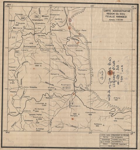
Carte administrative de la région du Kivu : Nyangezi
Cette carte administrative de Nyangezi au Kivu dans la République Démocratique du Congo (RDC) livre quelques informations politico-administratives relatives à cette entité.
Simple
- Date (Publication)
- 1981-01-01
- Date (Creation)
- 1981-01-01
- Date (Revision)
- 1981-01-01
- Citation identifier
- CD-CRSN-DOC526
Owner
Centre de Recherche en Sciences Naturelles (CRSN)
Lwiro
,
Bukavu
,
00000
,
République Démocratique du Congo
None
-
-
rdc
-
-
-
kivu
-
-
-
nyangezi
-
-
GEMET - INSPIRE Themes
-
-
Unités administratives
-
- Use limitation
-
None
- Access constraints
- Other restrictions
- Other constraints
-
Pas de restriction d'accès public selon INSPIRE
- Denominator
- 50000
- Language
- Français
- Character set
- MD_CharacterSetCode_utf8
- Topic category
-
- Boundaries
- Description
-
Liste des emprises
N
S
E
W
))
- Reference system identifier
- EPSG / urn:ogc:def:crs:EPSG:6.11:4209
- Distribution format
-
-
JPEG JFIF
(
)
-
JPEG JFIF
(
)
- Protocol
-
http
- Name of the resource
-
Centre de Recherche en Sciences Naturelles (CRSN) Lwiro
- Hierarchy level
- Dataset
Conformance result
- Date (Creation)
- 2010-11-23
- Explanation
-
See the referenced specification
- Pass
- Yes
- Statement
-
Cette carte de la région du Kivu (Feuille de Nyangezi) tracée en 1981 est l'oeuvre du Département de Géologie basée à l'Institut de Recherche Scientifique (I.R.S.) en Afrique Centrale (Lwiro).
- File identifier
- CD-CRSN-DOC526 XML
- Metadata language
- Français
- Character set
- MD_CharacterSetCode_utf8
- Hierarchy level
- Dataset
- Date stamp
- 2016-12-03
- Metadata standard name
-
ISO19115
- Metadata standard version
-
2003/Cor.1:2006
Point of contact
Centre de Recherche en Sciences Naturelles (CRSN)
Lwiro
,
Bukavu
,
00000
,
République Démocratique du Congo
None
Overviews
Spatial extent
N
S
E
W
Provided by

Associated resources
Not available