 Geocatalogue of the Royal Museum for Central Africa
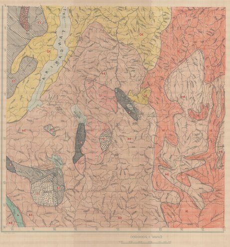
Hydrographie de Shaba, République Démocratique du Congo (RDC)
Cette carte renseigne sur l'hydrographie du Shaba en RDC (dans l'actuel Katanga) vers les années 1955.
Simple
- Date (Publication)
- 1955-01-01
- Date (Creation)
- 1955-01-01
- Date (Revision)
- 1955-01-01
- Citation identifier
- CD-CRSN-DOC538
Owner
Centre de Recherche en Sciences Naturelles (CRSN)
Lwiro
,
Bukavu
,
00000
,
République Démocratique du Congo
None
-
-
rdc
-
-
-
shaba
-
- Keywords
-
-
hydrographique
-
-
GEMET - INSPIRE Themes
-
-
Hydrographie
-
- Use limitation
-
None
- Access constraints
- Other restrictions
- Other constraints
-
Pas de restriction d'accès public selon INSPIRE
- Denominator
- 2000000
- Language
- Français
- Character set
- MD_CharacterSetCode_utf8
- Topic category
-
- Inland waters
- Description
-
Liste des emprises
N
S
E
W
))
- Reference system identifier
- EPSG / urn:ogc:def:crs:EPSG:6.11:4209
- Distribution format
-
-
JPEG JFIF
(
)
-
JPEG JFIF
(
)
- Protocol
-
http
- Name of the resource
-
Centre de Recherche en Sciences Naturelles (CRSN) Lwiro
- Hierarchy level
- Dataset
Conformance result
- Date (Creation)
- 2010-11-23
- Explanation
-
See the referenced specification
- Pass
- Yes
- Statement
-
Cette carte livre des informatons relatives à l'hydographie du Shaba (Katanga), elle a été réalisée par 8700-I.G.M. en 1955.
- File identifier
- CD-CRSN-DOC538 XML
- Metadata language
- Français
- Character set
- MD_CharacterSetCode_utf8
- Hierarchy level
- Dataset
- Date stamp
- 2016-12-03
- Metadata standard name
-
ISO19115
- Metadata standard version
-
2003/Cor.1:2006
Point of contact
Centre de Recherche en Sciences Naturelles (CRSN)
Lwiro
,
Bukavu
,
00000
,
République Démocratique du Congo
None
Overviews
Spatial extent
N
S
E
W
Provided by

Associated resources
Not available