 Geocatalogue of the Royal Museum for Central Africa
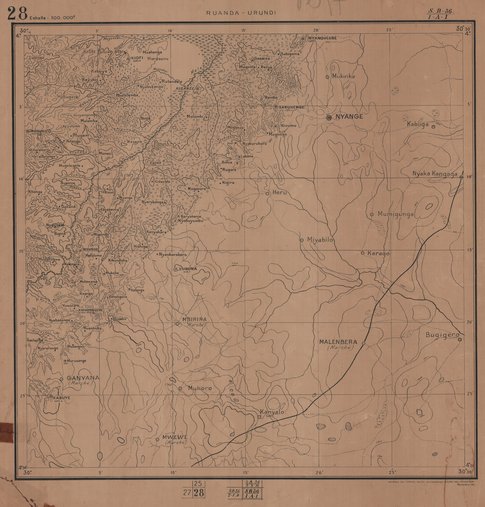
Carte administrative du Ruanda-Urundi
Cette carte administrative du Ruanda-Urundi (Rwanda-Burundi) donne des informations relatives à l'aspect politico-administratif vers les années 1925-1928-1931.
Simple
- Date (Publication)
- 1931-01-01
- Date (Creation)
- 1925-07-01
- Date (Revision)
- 1928-10-01
- Citation identifier
- CD-CRSN-DOC561
-
None
-
-
burundi
-
-
None
-
-
urundi
-
-
None
-
-
ruanda-urundi
-
-
GEMET - INSPIRE Themes
-
-
rwanda-burundi
-
-
GEMET - INSPIRE Themes
-
-
Unités administratives
-
- Use limitation
-
None
- Access constraints
- Other restrictions
- Other constraints
-
Pas de restriction d'accès public selon INSPIRE
- Denominator
- 100000
- Language
- Français
- Topic category
-
- Boundaries
- Description
-
Liste des emprises
N
S
E
W
))
- Reference system identifier
- urn:ogc:def:crs:EPSG:6.11 / 4258 / 6.11
- Distribution format
-
-
JPEG JFIF
(
None
)
-
JPEG JFIF
(
None
)
- Name of the resource
-
Centre de Recherche en Sciences Naturelles (CRSN) Lwiro
- Hierarchy level
- Dataset
Conformance result
- Date (Creation)
- 2010-11-23
- Explanation
-
See the referenced specification
- Pass
- Yes
- Statement
-
Cette carte a été traitée par le Service Cartographique avec l'assistance du Ministère des Colonies en juillet 1925. Elle a été mise à jour en octobre 1928 et ensuite en décembre 1931 .
- File identifier
- CD-CRSN-DOC561 XML
- Metadata language
- Français
- Character set
- MD_CharacterSetCode_utf8
- Hierarchy level
- Dataset
- Date stamp
- 2016-12-03
- Metadata standard name
-
ISO19115
- Metadata standard version
-
2003/Cor.1:2006
Point of contact
Centre de Recherche en Sciences Naturelles (CRSN)
Lwiro
,
Bukavu
,
00000
,
Belgique
None
Overviews
Spatial extent
N
S
E
W
Provided by

Associated resources
Not available