 Geocatalogue of the Royal Museum for Central Africa
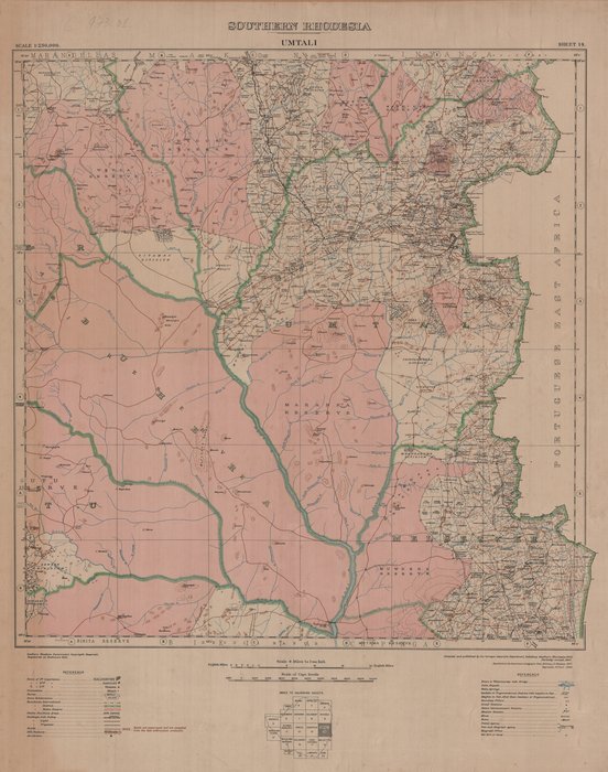
Umtali, Southern Rhodesia
Cette carte administrative de Umtali en Rhodésie du Sud (sheet 14) renseigne sur la localisation des villes de première importance, des rivières, des districts et des infrastructures vers les années 1929.
Simple
- Date (Publication)
- 1929-01-01
- Date (Creation)
- 1929-01-01
- Date (Revision)
- 1929-01-01
- Citation identifier
- CD-CRSN-DOC730
-
-
rhodesie
-
-
-
sud
-
-
-
umtali
-
-
GEMET - INSPIRE Themes
-
-
Dénominations géographiques
-
-
GEMET - INSPIRE Themes
-
-
Unités administratives
-
-
GEMET - INSPIRE Themes
-
-
Adresses
-
- Use limitation
-
None
- Access constraints
- Other restrictions
- Other constraints
-
Pas de restriction d'accès public selon INSPIRE
- Denominator
- 250000
- Language
- English
- Topic category
-
- Location
- Boundaries
- Location
- Description
-
Liste des emprises
N
S
E
W
))
- Reference system identifier
- urn:ogc:def:crs:EPSG:6.11 / 4258 / 6.11
- Distribution format
-
-
JPEG JFIF
(
None
)
-
JPEG JFIF
(
None
)
- Name of the resource
-
Centre de Recherche en Sciences Naturelles (CRSN) Lwiro
- Hierarchy level
- Dataset
Conformance result
- Date (Creation)
- 2010-11-23
- Explanation
-
See the referenced specification
- Pass
- Yes
- Statement
-
Compiled and published by the Surveyor General's Department Salisbury, Southern Rhodesia (1929). Partially revised, 1945
- File identifier
- CD-CRSN-DOC730 XML
- Metadata language
- Français
- Character set
- MD_CharacterSetCode_utf8
- Hierarchy level
- Dataset
- Date stamp
- 2016-12-28
- Metadata standard name
-
ISO19115
- Metadata standard version
-
2003/Cor.1:2006
Point of contact
Centre de Recherche en Sciences Naturelles (CRSN)
Lwiro
,
Bukavu
,
00000
,
Belgique
None
Overviews
Spatial extent
N
S
E
W
Provided by

Associated resources
Not available