 Geocatalogue of the Royal Museum for Central Africa
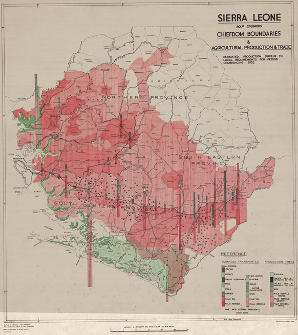
Sierra Leone, map showing chiefdom boundaries, agricultural production and trade
Cette carte livre des renseignements relatifs à la production et l'agriculture du Sierra Leone vers les années 1948.
Simple
- Date (Publication)
- 1948-01-01
- Date (Creation)
- 1948-01-01
- Date (Revision)
- 1948-01-01
- Citation identifier
- CD-CRSN-DOC828
Owner
Centre de Recherche en Sciences Naturelles (CRSN)
Lwiro
,
Bukavu
,
00000
,
République Démocratique du Congo
-
-
sierra
-
-
-
leone
-
-
GEMET - INSPIRE Themes
-
-
Unités administratives
-
-
GEMET - INSPIRE Themes
-
-
Installation agricoles et aquacoles
-
- Use limitation
-
None
- Access constraints
- Other restrictions
- Other constraints
-
Pas de restriction d'accès public selon INSPIRE
- Denominator
- 500000
- Language
- English
- Character set
- MD_CharacterSetCode_utf8
- Topic category
-
- Boundaries
- Farming
- Description
-
Liste des emprises
N
S
E
W
))
- Reference system identifier
- EPSG / urn:ogc:def:crs:EPSG:6.11:4209
- Distribution format
-
-
JPEG JFIF
(
None
)
-
JPEG JFIF
(
None
)
- Protocol
-
http
- Name of the resource
-
Centre de Recherche en Sciences Naturelles (CRSN) Lwiro
- Hierarchy level
- Dataset
Conformance result
- Date (Creation)
- 2010-11-23
- Explanation
-
See the referenced specification
- Pass
- Yes
- Statement
-
Reproduced by War Office 1948.
- File identifier
- CD-CRSN-DOC828 XML
- Metadata language
- Français
- Character set
- MD_CharacterSetCode_utf8
- Hierarchy level
- Dataset
- Date stamp
- 2017-01-25
- Metadata standard name
-
ISO19115
- Metadata standard version
-
2003/Cor.1:2006
Point of contact
Centre de Recherche en Sciences Naturelles (CRSN)
Lwiro
,
Bukavu
,
00000
,
République Démocratique du Congo
Overviews
Spatial extent
N
S
E
W
Provided by

Associated resources
Not available